Mapping Bangalore on the Arc
If our land had a way to tell a story, what tales would unfold! Take the historic battle of Bangalore, for instance, when the British took over Tipu’s stronghold in his own country, and made a base in Bangalore before attacking Srirangapatnam. It was an important event in the history of Mysore kingdom.
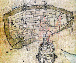
Standing at Bangalore’s Hudson circle or the Corporation Circle today, it is difficult to imagine the fort that surrounded what is today known as the Majestic area. In fact, it is hard to stand in this area without getting run over. It was a similar scenario in 1791 when the British laid siege to the Pettah fort. The firing of the cannons, the breach that took the lives of Col Moorhouse & several soldiers, the thick hedges the British had to get past, the courage of the defenders...When the British finally took over the Pettah, they were surprised to witness a prosperous city and its well laid streets that ‘few towns in Hindoostan that could boast of’.
As one delves into history or should we say geography, one realises that this important battle that altered the history of this region owed as much to British surveyors and engineers, as the soldiers.
Politics in the Deccan
A quick look into our geography books will tell us that South India is on an elevated flat land called the Deccan Plateau. This plateau is bound by Eastern and Western hill ranges or ghats.
The Vindhya and Satpura ranges border the land in the north and the ghats nearly meet at the Nilgiris at the South. In the 1700s, this geography played an important role in the politics of the area called the Deccan or what consisted of the Carnatic, Mysore and Malabar. Most of South India was ruled between the Nawab of Arcot and the Nizam of Hyderabad. The Carnatic region then meant the area between Krishna and the Kaveri (Coleroon) and from the Eastern ghats to the Bay of Bengal. As the English first made peace and later virtually ruled the Carnatic region, it was the Western region that was a thorn in their flesh for quite sometime. This was the old Mysore State. The elevated tract west of the Eastern Ghats was ruled by first the Mysore Wodeyars and later, Hyder Ali and Tipu Sultan.
As the English realised that they knew nothing “about the interior,” surveyors became all the more important. Once such person was Sir Alexander Beatson, who was the head of the Corps of Guides in the Cornwallis army.
Beatson relentlessly pursued exploring and surveying the whole of the Carnatic from river Godavari to Cape Comorin. During the 1790s, when war was imminent with Tipu, Beatson’s knowledge of every pass along the mountain ranges that separated Mysore from Carnatic and Travancore helped in the Mysore campaigns.
An extract of a military letter from the Hon the Court of Directors to the Government of Fort St George dated June 25 1793 says, “The performances of Captain Beatson whether of general Geography or of Sketches meant to convey ideas of particular spots of ground for military purposes or to form the elementary part of general geography appear to be executed with great judgment and accuracy. Some of the latter kind contain subjects of great importance such are the different passes and hill forts contained in Vol 3 of Geographical Observations sent on the Dutton and the elementary parts in the same volume will prove highly useful to Geography both general and particular.”
In fact his startling discovery of the Muglee Pass enabled Cornwallis to deceive Tipu Sultan and reach almost ten miles of the city with no opposition! The English army was met with stiff resistance, but they were successful in storming the Pettah and later conquering the adjoining oval fort. Though Bangalore then was just a smaller town in Mysore Kingdom, it gave the British a political advantage since it was a step away from Srirangapatnam. It was also a huge ego boost for them to beat Tipu in his own territory.
British historians mention these battles with pride. The battles are colourfully narrated by Fazlul Hassan in his book, ‘Bangalore through Centuries’. He quotes from the English historian, Wilks, about the sieges - ‘Few sieges have ever been conducted under parallel circumstances; a place not only invested, but regularly relieved by fresh troops; a besieging army not only undisturbed by field operations, but incessantly threatened by the whole of the enemy’s force’.
However he also attributes the success to “subversive activities of traitors who spared no efforts in helping the enemy by their heinous crimes.”
Mapping and surveying
Bangalore certainly did offer a great geographical advantage. It is in the centre of Southern India. Post 1800, when the British had conquered the entire Mysore Kingdom and set up a cantonment in Bangalore, there was a flurry of cartography of the entire region.
One of the earliest was Lambton, a Brigade Major, in the English army. He began his famous ‘Triangulation’ theory near Bangalore due to its location. His intentions were not only to survey and map the newly acquired region but also, through his findings, provide data to Geodesic studies that were earnestly researched in those days.
Geodesy is a branch of science to measure the size, shape, and gravity field of the Earth.
Geodesy supplies positioning information about locations on the Earth, and this information is used in a variety of applications, including civil engineering, boundary demarcations, navigation, resource management and exploration, and geophysical studies of the dynamics of the Earth. In ‘Deccan Traverses’, the authors Anuradha Mathur and Dilip Cunha describe of ‘a debate that raged in Europe in the first half of nineteenth century regarding the shape of the earth which Isaac Newton among others had declared was not a perfect sphere’. Some believed it was flat at the poles and some others believed that it was compressed at the equator. Hence the curvature of the earth, its shape and size became significant during this period.
Lambton, in 1806, started on the project of mapping a meridian from Bangalore to Cape Comorin.
The first experiments for this arduous journey were started at a place near Doddagunta. He reached Cape Comorin in 1808 and later returned to Bangalore to extend this arc northwards.
He died in 1826, but his work was taken up by others and the ‘Great Indian Arc’ crept towards the northern tip of India in 1878. Though the techniques have vastly improved today, the details of this long arduous journey created the first initial scientific survey of the region. This project became the framework for the surveys in India. Also, the city where it all began, grew in importance. From being a small trading town established in fifteenth century, Bangalore became a Sultan’s first frontier and finally got geographic importance in maps because of the work of British surveyors.