The path of water in Vijayanagara
One of the main reasons for the prosperous growth of the Vijayanagara kingdom (1336–1646), which was well-known for its art, culture, sculptures and architecture, was the importance its rulers gave to the water supply system. Sophisticated aqueducts and canals criss-crossed the cities and villages of the empire. Some of these centuries-old structures irrigate the agricultural fields even today.
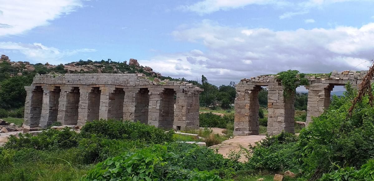
The presence of River Tungabhadra was one of the main reasons for the rulers to choose Hampi as their capital. Here, they built a system that would divert river water to several parts of their kingdom through anicuts (small dam), canals and lakes. One such stone wonder is the Bukka aqueduct. The aqueduct is a 200-metre-long structure and would carry water from Anegundi canal, which was a major water supply channel in the region, to Virupapur Gaddi island across the river. Though the bridge-like waterway is partially in ruins, it has not lost its charm.
Stone wonder
The aqueduct supported by 15-foot-tall pillars has been built using rectangular, dressed rock blocks and is plastered using mortar.
For the water to pass through below, the opening between each pillar is eight feet wide. These pillars have been constructed on rocky beds of the river. The unusual height of the canal makes it unique.
In Anegundi, on the side of a winding road that connects Anjanadri Hills to Huligi (Koppal district), one can find a portion of the aqueduct.
Seven kilometres from Anegundi, near Sanapura, the Tungabhadra river splits into two parts and the aqueduct stands across one of them. The aqueduct not only supplied water to the citizens of Vijaynagara but also served as a bridge, particularly for soldiers. Only half of its length survives today.
The 19-km-long Anegundi canal passes through various villages, ending at Sangapura lake, around 4.5 km from Gangavathi. Even today, this canal irrigates around 800 hectares of agricultural land for nearly 10 months a year.
In the past, the Anegundi canal used to carry water to the Veerupapur island through the Bukka aqueduct. The island has evidence of the presence of a fort and is thought to be an important defence camp. There are also large tracts of lands where paddy, banana and coconut are grown.
Currently, the link between the Anegundi canal and the Bukka bridge is in ruins. It is said that the damage might have been caused during a flood or during the Battle of Talikota in 1565.
History
Going by the name of the duct, the structure must have been constructed during the reign of Bukka Raya I (around 1356-1399). In the absence of any historical records, the exact details of the aqueduct are not available.
In many texts, there is a mention of the construction of a bridge (setu) near Hampi in 1380. It is said that Kampabhupa, who was a minister in the Vijayanagara empire, constructed it but it was meant for the movement of people and not used to carry water.
Researchers such as George Michell, Pierre- Sylvain Filliozat and Vasundhara Filliozat have shed light on a bridge in their works. Historian N Devakunjari documents that a bridge was constructed across the Tungabhadra in 1383. None of them, however, detail the link between the Anegundi canal and the duct or mention the name of the bridge.
In Hampi, one can see a Mettilu Kalyani (step well) near Mahanavami Dibba, Manmatha Honda besides Virupaksha Temple, Balakrishna Honda in front of Krishna Temple, Lokapavani Honda and many such ponds.
There are also heritage water structures like the Queen’s bath and the Octagonal bath. Elevated stone structures can be seen along the three-km-long canal that carries water from Kamalapur lake to the palace in Hampi.
Around one-and-a-half kilometre upstream is an anicut across the Tungabhadra, near Sanapura village. Information regarding all of these structures is well-documented.
However, there has been no study on the Bukka aqueduct. The locals call it the Bukka bridge, but the board of the Hampi Authority calls it a ‘bouldering site’.
Network of canals
There are 16 anicuts on both sides of the Tungabadra river, from present-day Hosapete in Vijayanagara district to Bichchali village in Raichur district. A majority of these were constructed during the Vijaynagara period. They irrigated around 20,000 hectares without submerging even an acre of land. These canals stand testimony to the intelligence of the builders then.
Studies about these anicuts reveal that even back then, water experts had scientifically identified these spots. The design of the canals was such that water would flow even though the water level was low.
Of the 16 anicuts of Vijayanagara, it was only through the Bukka aqueduct that water was supplied through a stone bridge at an elevation. All other canals were at ground level.
Not many tourists visit this aqueduct and there is no suitable authority that provides correct information. Those who visit wrongly assume it to be a bridge. Only few know of the ancient technology that served people around 600 years ago.
(Translated by Divyashri Mudakavi)