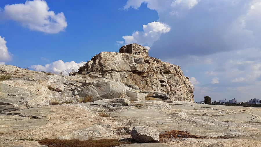
A GTS auxiliary station at Sampigehalli, Bengaluru.
Credit: Special arrangement
It was a bright, sunny morning sometime in 2010 in Kannuru, then on the outskirts of Bengaluru. One of us, Meera, followed waste management expert Almitra Patel as the 74-year-old ducked under branches and brushed past thorny shrubs, chatting about how her children used to clamber over the stone structure in front of us. It was an odd building, wreathed in wild vegetation, part hexagon and part rectangular, and with a gaping entrance. A circular pit inside was lined with stones but was far too small to be a well. A groove about a foot wide ran along two of the walls. Even more curious, the stone staircase from the terrace ended some two metres above the ground. Almitra had once met some scientists pottering about there, who told her it was part of an old survey.
Turns out the 1868 stone building was an observatory, part of the Great Trigonometrical Survey (GTS) of India, an ambitious mission to map the Indian subcontinent using scientific precision. This Survey didn’t just map India using triangulation, but also measured the height of the Himalayas (and determined that Mt Everest was the highest mountain in the world). It also played a major role in geodesy — measuring the shape of the Earth.
This 1870 map shows the network of principal triangulations across India. Source JT Walker. 1879. An Account of the Operations of the Great Trigonometrical Survey of India, Vol 2 History and Description.
Triangulation is a technique that makes use of the properties of a triangle. If you know the length of one side and two of the angles, you can calculate the lengths of the other two sides using simple trigonometry. A location can then be determined by measuring angles to it from both ends of a fixed baseline. We outline all this and more in our recent book ‘India in Triangles: The Incredible Story of How India was Mapped and the Himalayas Measured’ (Penguin Random House India).
Testing in Bengaluru
This gargantuan project had its beginnings in our own Bengaluru. It all began in October 1800, when William Lambton, an officer in the East India Company’s army, established his first baseline. It was about 12 km long, and ran from near Haralur in the south to Ramamurthy Nagar in the north.
Or perhaps it began even earlier. The GTS was Lambton’s brainchild. He followed a scientific debate about geodesy at the time, and wanted to understand exactly how the Earth was shaped at the tropics. He wanted to draw accurate maps of the subcontinent. In 1799, the idea of preparing good maps aligned perfectly with the East India Company’s expansionist policies. They approved Lambton’s project and he began working on it in Bengaluru.
The first order of business was a trial project which lasted almost two years. Lambton and his team began by taking bearings (angles measured from a fixed point) and calculating distances to landmarks and locations familiar to all of us. These were the first triangulations of the survey. One of the first recorded data points was the bearing to the Kempegowda Tower near Ballari Road. They calculated distances to temples and trees, and to all the hills that circle the city, including Savanadurga, Bettahalasur, Nandi Hills and Shivasandra. Lambton continued triangulating all the way to Srirangapatna, where he established another baseline, still as part of the initial tryout.
Madras milestone
In April 1802, when some long-awaited equipment finally arrived from England, Lambton headed over to Chennai. That is where the survey officially began. Lambton established a 12.2 km baseline that ran from the Madras Race Club in Guindy to a point near Sholinganallur.
Then began triangulations. They hauled the so-called Great Theodolite up and down hills and towers. This instrument, used for measuring angles both horizontally and vertically, infamously weighed half a tonne. They lugged the equally heavy telescope called the Zenith Sector across forests, villages and streams. Men stayed up nights to measure azimuths (angles measured clockwise from north) and to sight lights lit by their colleagues many miles away. And they calculated, carefully; laboriously; assiduously.
And slowly, they constructed a network of imaginary triangles across the land, plotted the coordinates of many places for the first time, and drew inch-perfect maps. A long line of triangles along the central spine of the country from Kanyakumari to Dehradun, via Bengaluru and Bidar, provided the data to calculate the sphericity of the Earth at the tropics, something hitherto unknown. This in turn formed the basis of all maps made in the country until about the 1990s.
The GTS observatory in Kannuru, Bengaluru, before it was restored by INTACH in 2021. It was demolished by an unidentified person last year.
Credit: Special arrangement
The GTS produced another dataset of global interest. This was the measurement of the heights of Himalayan peaks which established Mt Everest as the tallest mountain in the world. This exercise involved the gifted Indian mathematician Radhanath Sikdar. Today, we have calls from some quarters for Mt Everest to be named after him rather than after the brilliant but irascible George Everest, who helmed the GTS after William Lambton’s death.
The GTS was built on mathematics and science. But it was the courage, ambition and determination of the surveyors that powered it through about a hundred years. Especially, in its early years, the surveyors faced and surmounted numerous setbacks, from bureaucratic hurdles to bandits to debilitating disease.
Digging into archives
After that first memorable encounter with the GTS observatory in Kannuru, Meera’s engagement with the GTS was revived when she was involved in the restoration of the structure by the Indian National Trust for Art and Cultural Heritage (INTACH). She is the convenor of its Bengaluru chapter. She also wrote about the Kannuru observatory and the GTS in this newspaper. Shruthi read these articles, and found a potential kindred spirit. A children’s author, Shruthi had been fascinated by the GTS for a few years then, and had wanted to bring this astounding but little-known story to young people. She got in touch with Meera.
Co-authoring isn’t for the faint-hearted. It requires mutual trust and respect, as well as the willingness to discuss and come to an agreement if there is a difference of opinion. We got into this groove quickly. Being in two different continents and time zones felt daunting at first, but it turned out to be an advantage. Like a relay, we worked on it on our time, and handed over the baton, as it were, to each other at the end of our day.
Telling the story in a way that is more accessible to readers meant that we first needed to understand some of the practicalities and nitty-gritties ourselves. How does one actually measure a baseline, how would you ensure that a line several kilometres long is absolutely straight, and what exactly did surveyors use to sight distant places at night? The questions were many as we grappled with context, seeking to understand in clear terms the history, science and mathematics of the concept of triangulation.
A large and important part of telling the GTS story was to understand how Indians figured in it. The phenomenal work that Lambton, Everest and others put in is deservedly praised, but we wondered about historical and social perspectives that aren’t present in other accounts of the GTS. We wanted to know how ordinary people felt as they saw survey parties barging into their villages, farms and forests, or stomping over sacred spaces. And we wanted to know more about the unsung Indians who worked alongside the celebrated surveyors. Not surprisingly, there are not too many details about them. For example, we know next to nothing about Chitan Katan from Chennai, who worked as a flagman with the GTS from the early 1800s until his retirement. We know even less about Sheikh Ahmed, an armed guard with the GTS party, even though he too dedicated his entire career to the GTS. One report praises the men who carried the Great Theodolite as being ‘an important element’ of the survey party but we do not know their names.
Others before us have been fascinated by this project and we devoured books about the GTS by John Keay, Matthew Edney and Riaz Dean.
We weren’t trying to present new research. That said, there was also little out there about Lambton’s preparatory work — the trial baselines he set up in Bengaluru and later in Srirangapatna. We had to go back to files in the National Archives of India, the Karnataka State Archives, and the records of the Survey of India.
Some of the most riveting parts of the research were looking through such archival records. There are dull documents, and then there are those that speak to you directly from the past. Peer long enough at a page of slanting, cursive text, hand-written in ink and you feel like you know the person who wrote it, you recognise their style. Every familiar name of a person or place from a letter written 200 years ago led to a frisson of excitement. So we were thrilled as we read about the sightings from the first baseline to the Kempegowda Tower off Ballari Road, the ‘Muntapam’ as he called it, and the many temples including at Nanjangud and Srirangapatna that came in useful in the survey.
The southwest end of the Bengaluru baseline marker is located inside the Ramana Maharshi Park near the Kempegowda Tower off Ballari Road.
Credit: Special arrangement
And then, there were online repositories that enabled us to read Lambton’s original publications at the touch of a button. These were written to be read by his peers in the 1800s which meant they were long but obtuse. And they were obviously but frustratingly silent on details we wanted to know. For example, how long did it take them to climb Nandi Hills along with all that equipment?
We also encountered stories of surveyors outside of the GTS, such as the so-called pundits. They pretended to be Buddhist priests so that they could access otherwise-forbidden regions like Nepal and Tibet. These ersatz pilgrims surveyed hostile terrains using pocket-size sextants, faux prayer wheels and rosaries, and other such inventive means.
Relics in plain sight
Perhaps the most exciting facet of this scientific endeavour is that there are tangible remnants of the GTS almost everywhere in the country. In fact, Shruthi’s interest in the GTS began with one such relic. In 2014, on a touristy visit to Mussoorie, Uttarakhand, Shruthi stumbled upon the house of George Everest in Hathipaon. At that time, it was a dilapidated shell, full of graffiti and cow droppings, but it was quite clear to her that this house, standing in such a stunning location, hadn’t been just a thing of beauty. Upon research, she discovered that Everest wasn’t just a random fellow who lent his name to the mighty mountain, and heard about the GTS for the very first time.
The most ubiquitous relics of the GTS are the benchmarks, small markers that were erected where surveyors accurately measured elevation. In Bengaluru, there are benchmarks on the steps of the Kempegowda Tower on Ballari Road and on old churches such as Trinity Church. They can also be seen on railway platforms and bridges, as well as on the pedestals of old statues across the country. They also turn up in some unexpected places. In Karnataka, we have seen benchmarks chiselled into the steps of a dilapidated 11th century Kalyana Chalukya temple near Hanagal, and a sluice gate in Srirangapatna. In eastern India, you can see several towers that were used by surveyors, in various states of preservation. A few years ago, scholars from the University of Calcutta and Queen’s University in Belfast undertook a survey to document these towers.
In the rest of the country, these vestiges of the GTS are rapidly being lost to urbanisation, vandalism and ignorance. The surveyors recorded GTS benchmarks on structures they thought would last a long while, but many that were recorded on platforms, churches and milestones have disappeared. The GTS observatory in Kannuru was demolished by an unidentified person last year and the revenue department filed a case following public outcry. A moment’s silence here, dear reader, for this event occurred even as we were writing our book. It shattered our hearts.
A few years ago, heritage activist Udaya Kumar P L went around looking for and documenting the remains of the baselines and auxiliary stations that surveyors established in Bengaluru. Imagine if citizens elsewhere in the country could similarly undertake to document the benchmarks, towers and baselines in their backyard. These could then be entered into a single platform to create a country-wide, citizen-built database of these bits of scientific history.
But why, you may wonder. Why need anyone bother about these relics when we have moved far beyond GTS to the age of GPS. For one thing, these old structures and benchmarks serve as entry points for people to think about how science and surveying served the Empire. They remind us how simple ideas like trigonometry can form the basis for grand ideas like geodesy. And they hold stories of the courage and vision of surveyors, mathematicians, flagmen and others, all of whom were part of a project that was larger than any of them.
Like this story? Email: dhonsat@deccanherald.co.in