
The country’s remote sensing satellite launch capabilities got a boost on Thursday with the successful launch of the indigenous Radar imaging Satellite (RISAT-1) from the Satish Dhawan Space Centre, around 100 km north of Chennai.
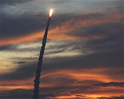
The Indian Space Research Organisation’s (Isro) Polar Satellite Launch Vehicle (PSLV-C19) successfully launched RISAT-1 on the desired orbit, thus reducing India’s dependence on countries like Israel that uses microwave signals to capture images of the earth.
RISAT-1 is a variant of microwave remote sensing satellite (MRSS) and is equipped with a synthetic aperture radar payload in the C-band (5.35 GH) frequency. It scores over the previously used optical remote sensing satellites which could capture images during the day only. The Isro had previously launched the Israel-made RISAT-2.
At 5:47 am on Thursday morning, the 44.5 meter long PSLV-C19, weighing 321 tonne, took off from a launch pad, before ejecting the satellite into the desired polar circular orbit at an altitude of 480 km after 18 minutes. A team of scientists led by Isro Chairman K Radhakrishnan were monitoring the flight from the New Mission Control Centre here.
Cherishing the successful launch, scientists present at the launch revealed that RISAT-1, weighing 1,858 kg, is the heaviest satellite launched by a PSLV launcher till date. The PSLV-XL variant had earlier launched Chandrayaan-1 and GSAT-12 communication satellite.
“At the moment, the satellite is pointing towards the earth and in the next three days its orbit will be taken to its final destination at an altitude of 536 km and after further operations its imaging operations will start from May 1,” Radhakrishnan said before reading out Prime Minister Manmohan Singh’s congratulatory message.
Dismissing speculations that RISAT-I was a spy satellite, since RISAT-2 was used for surveillance operations, Radhakrishnan said: “It has been launched to help the government to assess crop prospects, particularly the kharif crop, imaging soil conditions and study flood-hit areas in extreme conditions like a Tsunami.”
“This radar imaging satellite, using micro-wave principle, is in the C-Band, while RISAT-2 was in the X band,” he added.