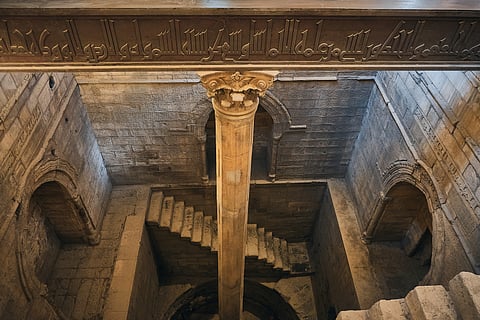
Long before river gauges or satellites existed, ancient Egyptians used stones to read the Nile’s behaviour. Along the riverbanks in places like Elephantine Island in Aswan, the Temple of Kom Ombo, and Old Cairo, they built carved stone structures called nilometers — elegant stairways, pillars, and wells marked with lines and hieroglyphs. These marks acted as the civilisation’s first water-level recorders.
Every year, priests would descend the stone steps and note where the water touched the carvings. A high mark meant the river had flooded well and the farmlands would thrive. A low mark warned of drought and poor harvests. Because the Nile’s flood determined everything — food, survival, and even tax levels — these stone measurements were treated with almost sacred seriousness.
Carved precision
Marks showed water height to within a few centimetres — incredibly accurate for the ancient world.
Temple duty
Priests interpreted readings and announced whether the gods had blessed Egypt with a good flood.
Taxation link
Harvest size — and the year’s taxes — were set based on nilometer readings.
Some nilometers had vertical columns submerged in the river, with measurement markings etched in cubits. Others, like the stairway at Elephantine, allowed priests to walk down and physically observe the rising water. Over centuries, these stones collected a continuous climate record, capturing wet years, dry years, and the river’s long-term rhythm.
Though the world around them has changed, many of these ancient markers still stand. Their carved lines remain visible, showing the story of a river that fed a civilisation and the people who learned to read water through stone.