Last Updated IST
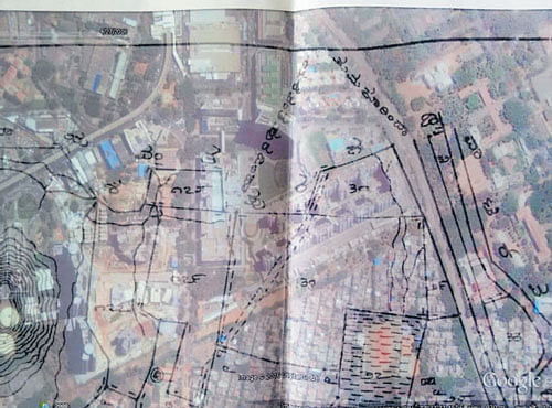
The village map superimposed on Google Earth image shows a stormwater drain running in the middle of the mall.
Orion Mall on Rajkumar Road may run into big trouble as a survey sketch with a detailed report prepared by Bengaluru Urban district authorities shows that the commercial space is sitting on three acres and four guntas of government land.
In his September 2 report to the Commissioner of Survey, Settlement and Land Records, Joint Director of Land Records K Jayaprakash stated that the encroachment happened in nine survey numbers of Kethumaranahalli and Yeshwantpur villages of Yeshwantpur hobli, Bengaluru North taluk.
The land comprises a stormwater drain, pathway, bullock cart way, erstwhile village road, rock area and pond. The encroached land has been described as ‘kharab’ (wasteland). The century-old village map had all the topographical details.
“While preparing the local map, the village maps were not taken into account. As a result, these minute details did not find mention in the local maps prepared in the later years, which is a blunder,” the joint director stated in the report. He has requested revenue officials to initiate action for the recovery of government land.
In support of the claim, Jayaprakash submitted the village map superimposed on Google Earth satellite images, which show the stormwater drain running right in the middle of Orion Mall. Five days ago, Mayor B N Manjunath Reddy had accused Brigade Group of encroaching on the stormwater drain for Orion Mall. The builder categorically denied the charge.
Deccan Herald is on WhatsApp Channels| Join now for Breaking News & Editor's Picks