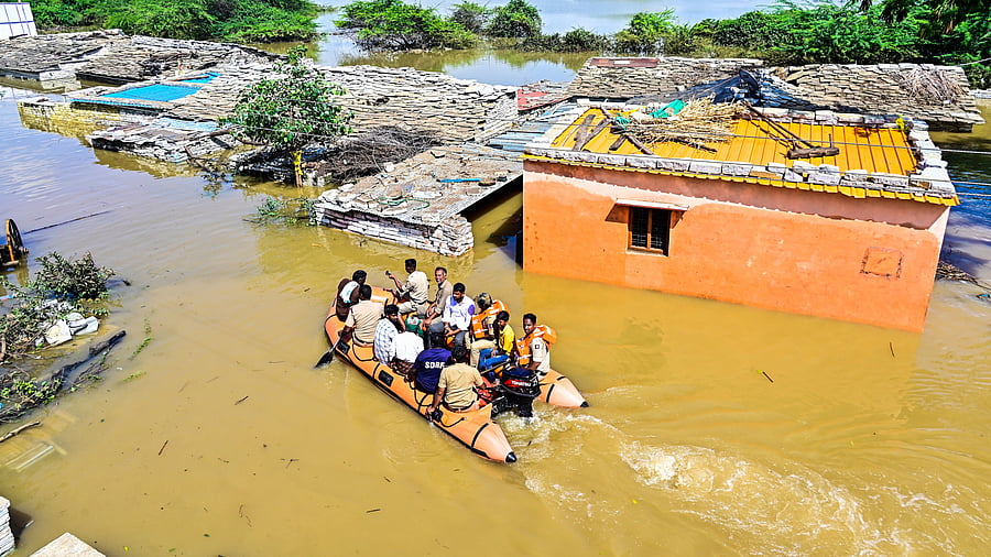
Fire and Emergency Services and State Disaster Response Force personnel evacuate residents of Kadabur village in Kalaburagi district to safer locations after flooding of the Bhima River.
Credit: DH Photo
Bengaluru/Kalaburagi: Forty-four-year-old Hanumant Shahabad, a farm labourer from Mandarwad in Jewargi taluk, relocates with his family every time the water released from reservoirs in Maharashtra swells the Bhima river. They stay with relatives in Kalaburagi or in rented accommodations, returning only after the waters recede.
Hanumant is not alone. Nearly 200 households in Mandarwad endure sleepless nights during the monsoon watching river levels rise and waiting for evacuation. In response, the government constructed around 100 small houses at a rehabilitation site nearby but the houses lack basic amenities such as proper roads, electricity and drinking water. More importantly, villagers say they are too small to store food grains and fodder, and accommodate cattle. As a result, only 15 are occupied, while the rest have fallen into poor condition.
“We need a permanent solution, new homes in safer locations,” says Anusuya, a resident of Kobal village in Jewargi taluk.
The situation is no different in Bagalkot, Vijayapura, Gadag, Dharwad, Raichur and other parts of the region affected by flooding caused in the Malaprabha, Ghataprabha, Bhima, Doni and other tributaries of the Krishna.
Similar flooding occurs in central Karnataka, where Kumbaragundi and surrounding areas along the Tunga river in Shivamogga district get inundated when large volumes of water are released from the Tunga dam at Gajanur. Bhadravathi town faces similar flooding due to releases from the Bhadra Dam.
Floods are the most visible natural disasters in Karnataka. But they are only part of a wider spectrum of disasters, visible and invisible, that plague the state. Despite decades of experience with recurrent flooding, official responses have largely remained reactive, focused on evacuation, compensation and temporary shelters, rather than on preventive planning and durable solutions that reduce risk over the long term.
In August 2025, the government released the Karnataka State Disaster Risk Reduction (KSDRR) Road Map 2025–2030, a forward-looking, action-oriented policy framework developed by the Karnataka State Disaster Management Authority (KSDMA) with technical support from UNICEF, aimed at making Karnataka disaster-resilient by 2030. The document outlines action items for 20 government departments.
On paper, the document is ambitious. It emphasises mitigation, preparedness, climate adaptation and inter-departmental coordination. However, the timing is a major concern. According to a recent Comptroller and Auditor General (CAG) report, the disaster risk reduction policy itself was approved in 2020, nearly 12 years after the KSDMA was constituted. The preparation of roadmap to implement that policy took another five years.
“The roadmap has taken so much time that parts of the policy risk becoming outdated even before full implementation,” says a disaster management expert.
The document, along with robust disaster-response steps, highlights many mitigation techniques. However, experts believe it could have been better.
Even today, large parts of north Karnataka remain trapped in a cycle of floods, crop loss and displacement.
In Belagavi district alone, more than 200 villages are affected by floods during the monsoon. Waters of the Krishna spread across the villages and towns along its course after inflows from Maharashtra exceed 3.50 lakh cusec. This year, 20 villages were fully submerged, and 190 were partially affected.
To manage the risk, the district administrations in Kolhapur and Sangli share real-time data on downstream water releases with Belagavi district officials during the monsoon. This coordination allows for calibrated discharges from the Hippargi barrage and the Almatti dam. Yet, despite these arrangements, flooding continues year after year and so does displacement.
Kalaburagi district illustrates the cumulative toll of such recurring extremes. A GI-tagged tur-growing region, it has faced both droughts and floods almost every year since 2000. Over the past three years, farmers have received a record Rs 2,171 crore in input subsidies and crop insurance payouts. Even so, these measures have failed to offset the long-term damage caused by repeated natural disasters.
“We have separate teams monitoring rainfall in Maharashtra and water releases from the Ujjani dam through dedicated teams and alert residents along the Bhima river accordingly,” says Afzalpur tahsildar Sanjeevkumar Dasar. “But increasing storage capacity in existing reservoirs is a policy decision that requires inter-state agreement.”
The scale of loss remains staggering. This year, heavy rainfall and flooding damaged crops on 3.24 lakh hectares of the district’s more than nine lakh hectares under cultivation. Agricultural experts stress the need for structural changes — multi-cropping, annual crop rotation and risk-spreading practices — to reduce farmers’ vulnerability.
For many cultivators, however, survival has become the priority. “I have the responsibility of raising my three young children, and this year’s crop loss has pushed us deeper into debt,” says Gayatri Jadhav, a Lambani woman from Kadadur village in Kalagi taluk. “We borrow from banks and private lenders to pay for leased land. Frequent droughts and floods have made farming unviable.”
Compensation, farmers say, offers only temporary relief. Each year, they must navigate bureaucratic processes to access it, even as the underlying risks remain unchanged.
The KSDRR roadmap and policy acknowledge these losses, proposing crop insurance, improved irrigation coverage and sustainable water and crop management. Whether these commitments will move beyond documentation and translate into on-ground implementation remains an open question — one that farmers in Karnataka’s most vulnerable regions can no longer afford to wait to have answered.
Dealing with drought
The lack of adequate water storage infrastructure is a fundamental weakness in north Karnataka’s disaster preparedness. Experts point out that the region has limited capacity to store water through dams, barrages and lakes, leaving it vulnerable to both floods during the monsoon and drought in summer.
Across Kalaburagi, Yadgir and Bidar districts, all 11 existing dams together have a storage capacity of just 24.721 tmc. Increasing this capacity, experts say, could significantly expand irrigation coverage and reduce chronic drought conditions.
The Bhima river illustrates the imbalance. Originating in the Western Ghats of Maharashtra, the river flows for about 861 km through Karnataka and parts of Telangana before joining the Krishna in Raichur district. Farmer leaders argue that expanding the storage capacity of existing barrages and rejuvenating lakes, for which tenders have already been floated, would allow the state utilise more water. They estimate that this could bring over two lakh hectares of farmland under irrigation and ensure drinking water supply to several villages and towns during the summer.
The inter-state water sharing further complicates the picture. The Justice R S Bachawat Commission, in 1976, allocated 300 tmc ft of Bhima water to Maharashtra, 45.3 tmc ft to Karnataka and 5.1 tmc ft to Andhra Pradesh, out of a total of 351 tmc ft. Farmer leaders in Karnataka claim that Maharashtra utilises 140 tmcft, water beyond its allocation, limiting downstream availability. While such assertions are contested and require legal and technical scrutiny, the outcome on the ground is evident: The Bhima river is drying up because Maharashtra is not releasing its share of 15 tmc of water, resulting in severe drinking water scarcity and drought every summer.
Managing this seasonal paradox — excess water during the monsoon and scarcity in summer — remains one of the region’s biggest challenges.
The KSDRR roadmap acknowledges water scarcity and calls for sustainable water management and conservation. But it remains silent on legal remedies, inter-state negotiations and the expansion of storage infrastructure.
One such unresolved long-term proposal is the balancing reservoir at Navali in Kanakagiri taluk of Koppal district, intended to locally store surplus water. Discussions on the project began 11 years ago. While the Congress government initially committed to it, a detailed project report costing Rs 13,040 crore was prepared three years ago under the BJP government. Since then, the project has remained in cold storage. The roadmap is silent on such long-term projects as well.
A clarification issued by the office of Revenue Minister Krishna Byregowda states that the State government, through the Water Resources Department, has constituted the State Dam Safety Authority and the State Committee on Dam Safety. It adds that regular consultations on preparedness and data sharing are held ahead of the south-west monsoon with neighbouring states including Maharashtra, Kerala and Telangana.
The clarification further notes that dedicated WhatsApp communication groups have been created for the Krishna and Tungabhadra river basins, comprising officials from Maharashtra, Karnataka, Telangana and Andhra Pradesh. These groups share real-time information on reservoir water levels, inflows and outflows, enabling timely coordination and improved downstream flood preparedness.
Extreme heat and cold
Kalyana Karnataka is increasingly witnessing sweltering heat and severe cold every year. In 2023, Bidar recorded a low of 5.5 degrees Celsius, the coldest in a decade. Recently, for the first time, the state issued a coldwave alert in the region, a step towards acknowledging cold as a disaster risk. Yet the KSDRR roadmap does not explicitly recognise coldwaves as a disaster relevant to the state, nor does it outline measures to reduce their impact.
“Coldwaves cannot be prevented, but their impact can be significantly reduced through better infrastructure and early-warning systems,” says a disaster management expert.
If winters are severe, summers are unforgiving. Temperatures routinely climb to 45 degrees Celsius in districts such as Kalaburagi, Yadgir, Raichur and Ballari, leaving residents with little respite. All districts in the region experience heatwaves during April and May, with temperatures crossing 44 degrees Celsius in Yadgir, Raichur and Bidar districts.
The heat is so intense that water flowing from taps turns hot by 10 am. Each year, the government responds by advancing office hours to 8 am–1.30 pm in nine heatwave-affected districts, while health officials advise people to stay indoors between noon and 3 pm to prevent heat-related illnesses, including heatstroke.
“The extreme temperatures are linked to the region’s flat terrain and limestone deposits, which absorb and radiate heat,” explains Basavaraj Biradar, technical officer at the Bidar Agriculture Research Station and the India Meteorological Department.
The human costs are evident. Residents report blisters on their heads and bodies, dehydration and chronic fatigue. The economic impacts are equally severe. Livestock losses mount, the dairy sector suffers, and productivity declines as prolonged heat takes a physical and mental toll on people.
Local administrations have responded with immediate relief measures — shade structures at busy intersections and Amrut Neralu huts at several locations that provide drinking water and temporary respite. However, these are short-term measures.
What is missing, experts say, is a region-wide strategy to reduce heat exposure itself: expanding green cover through parks and tree plantations, promoting drought-resistant vegetation and improving water storage systems.
In agriculture, heat-tolerant crop varieties, agroforestry, soil moisture conservation, a shift to less water-intensive crops and innovations such as agrivoltaics — solar panels installed above farmland that provide both electricity and shade — can help mitigate heat when well planned.
While the roadmap speaks of heat-resistant infrastructure and solar energy in urban areas, it offers little by way of a clear, scalable mitigation plan for rural and agrarian regions like Kalyana Karnataka, where exposure is highest and coping capacity is weakest.
Risks from the sea
With a 320-km-long coastline, the state faces persistent coastal risks. The state’s disaster management policy and roadmap recognise sea erosion as a disaster and allocate funds to address it. However, the roadmap does not mention how those funds will be utilised.
In Mangaluru, the risks are immediate and recurrent. Low-lying areas around Kottara Chowki are routinely flooded when high tides prevent stormwater drains from discharging into the sea, a problem that intensifies during heavy rainfall.
Babloo Chaudhary, assistant professor of civil engineering at NITK Surathkal, who has worked extensively on disaster mitigation, including tsunamis and landslides, notes that disaster mitigation efforts have not prioritised community-level protection. While a centrally funded project has strengthened the rubble-mound breakwater at New Mangalore Port, such measures do little to address routine flooding in surrounding areas.
Equally concerning is the lack of robust early-warning systems for hazards such as landslides, which frequently occur in the coastal belt and the Western Ghats during the monsoon. At NITK, Chaudhary’s team is developing a multi-level landslide early-warning system at the laboratory stage, featuring on-site sirens, alerts to local authorities and potential mobile notifications using GPS and rainfall thresholds. However, the system requires large datasets, sensors, substantial funding and government adoption for real-world deployment.
While the government roadmap refers to mobile-based early-warning messaging, it provides little clarity on implementation, maintenance or localisation. This gap matters because disaster risks and effects are highly localised, and so are mitigation strategies.
In Dakshina Kannada, for example, the Phalguni river frequently floods agricultural fields and residential areas in Adyapadi, causing major disruption. In response, a recent initiative by the Vana Charitable Trust, in collaboration with the Syngene Biocon Foundation, the Centre for Advanced Learning and government departments, has launched a mangrove restoration project along the Nethravathi riverbank in Mangaluru. The project aims to rehabilitate 54 acres of mangroves over five years to protect the coastline, using nature-based solutions to buffer floods and stabilise the coastline.
In 2021, the state trained around 3,400 volunteers, now known as Apadmitras, in disaster management concepts and basic lifesaving techniques. Experts, however, have criticised the government for failing to equip these volunteers with protective gear, limiting their effectiveness during emergencies.
A trained volunteer from Hassan, who spoke to DH, said that despite these constraints, the training remains valuable. “We do whatever we can before the State Disaster Response Force and the National Disaster Response Force battalions arrive when a calamity strikes,” the volunteer said.
The government has since expanded the programme by training Yuva Apadmitras, young volunteers drawn from the NCC, NSS, Scouts and Guides, to strengthen first-response capacity at the local level.
In its response, the Revenue Minister’s office stated that disaster management at the gram panchayat level depends significantly on local NGOs for relief and response. It added that disaster risk is evolving, with emerging threats such as heatwaves and that the policy framework is dynamic and intended to adapt to new and emerging risks over time.
Ultimately, effective disaster management in Karnataka demands localised, well-funded and scalable strategies that address immediate risks while building long-term climate resilience.
(With inputs from Harsha and Naina J A in Mangaluru, Nrupathunga S K in Davangere and Raju Gavali in Belagavi)