The south interior region of the State is largely a flat plateau. But the seemingly level landscape is punctuated with numerous hills. The moderately high hills with steep granite slopes, huge boulders and caves were most suitable for building fortresses from where rulers and chieftains could stay safe and rule their provinces. Some of these rocky hills also turned out to be famed hill temples such as Shivagange, Siddagange and Devarayana Durga to name a few.
Channarayana Durga is a tall shapely rocky hill situated between Koratagere and Madhugiri about 95 km from Bangalore. Standing at a height of 3,734 ft, it has steep slopes, making it rather tricky to approach it. A formidable fortress was built here somewhere during the middle of the 17th century.
According to records, Channappa Gowda, a chieftain of Madhugiri, built the fort. The hill fort has probably been named after him. The fort changed hands frequently and alternately between the Marathas and the Mysore kings.
After losing one such battle to the Marathas, the local chief had to seek refuge at nearby Madhugiri for two years before he could annex it again and rule for about eight years. Later it was won over by a general of the Mysore king, Komaraiah. After a brief siege by the British, the place was abandoned.
Still standing tall
The solid stone fort stands tall and strong. The conical outline of the hill with the fort at the top, much like a crown, catches the eye. Without proper steps or a clear path, the initial climb is no easy task. The only way to reach the top is by scrambling up the moderate slope from the southern side. You can ask anyone from the little village at the base to show the way.
The outermost wall of the fort has well-built rectangular ramparts with one of them having an entrance from the west. It is followed immediately by another gate leading to an open area with two paths. The trail to the left takes one up to an exposed structure in the west while the other path goes to the fort. Though the fort is by and large sturdy, a few pillars and stones have crumbled and block the entrance.
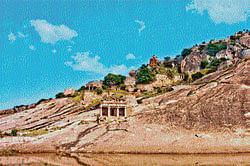
Passing through this gate with some effort, I came to a very wide rocky plateau with a lovely tank of green transparent water. The vastness of the area and the water body must have easily supported a small population within the fort in the days of yore. On the western bank is a fine temple without any idol. The huge circular granary here was used to store water.
On the left is another gate with a floral design above leading further into the fort. On the right are many ruined rectangular mantapas that look like houses.
All along, the path is guarded by a massive stone wall. When you reach the summit through a northern gate, there is an open space with ruins of what must have been the residence of the chief. There are also a couple of niches with passages designed as an escape route.
The southern wall at the top has three sides with artistic window openings. The valley view in the north with hills and bushes is an amazing one. To the south is a lovely lake and the village. On the way down, you can see a temple on the right side which is ruined not so much by the elements as by the vandals who have dug up all over in search of treasure.
In the village is a shrine of Annapurneshwari and Murarimatha, where padukas of a saint are worshipped.
Getting there
Drive on Tumkur Road (NH 4) to Dobbspet; take a right to Koratagere and further to Tumbadi village. Here, take a left for four km and a further two km to the right.
Deccan Herald is on WhatsApp Channels| Join now for Breaking News & Editor's Picks