Restoring a relic of science
In December last year, the Chinese and Nepalese governments revised the height of Mt Everest from 8,848 m to 8,849 m. Coincidentally, this was the same time that work began in Bengaluru to restore a monument from a scientific survey that determined the height of the world’s tallest mountain 150 years ago.
The journey to Mt Everest began in Bengaluru in 1800, when Brigade-Major (later Colonel) William Lambton wrote to the East India Company’s governor in Madras. He proposed a “Mathematical and Geographical Survey” across the peninsular “for determining the principle geographical points...”
In other words, an accurate map. And the larger purpose—to determine the shape of the earth.
In the late 1600s, scientists debated whether the earth was oblate, meaning flattened at the poles, or prolate, flattened at the equator.
In the early 1700s, researchers found that a degree of latitude at the equator measured less than a degree near the North Pole, thus proving that the earth was an oblate spheroid.
But what exactly was the curvature of the earth?
Lambton hoped to answer this question using triangles. The principle of triangulation is simple: If you know the exact distance between two points and then measure the angles from these points to a third, you can then calculate the distance and position of the third point using trigonometry.
He proposed to cast a net of triangles all over India and hence map the land accurately and also determine the shape of the earth. Lambton’s survey was later christened the Great Trigonometrical Survey, or GTS.
First GTS baseline
In October 1800, Lambton began constructing the first ever GTS baseline in Bengaluru, from near Agara to Ramamurthy Nagar. Using this baseline, over the next year, he extended several triangles all the way to Srirangapatna. Satisfied with this pilot, Lambton officially began the GTS in 1802 in Chennai, triangulating his way from there across the peninsula.
Bengaluru’s second baseline was established in 1804 by Lieutenant Warren, near the Kempegowda Tower on Bellary Road. This baseline formed the basis of subsequent triangulation till the 1860s.
Early baselines were measured with 100-foot steel chains. Several men had to heft the chain into coffers which were supported on stands that had to be perfectly level. Corrections were required for thermal expansion and contraction in different weather conditions.
Lambton’s theodolite needed 12 people to lug it around. George Everest, who took over after Lambton, introduced new tools that were more accurate but required far more laborious toil.
Peering through microscopes all day and through telescopes at night to determine latitudes, waiting for clear days and nights, progress was necessarily slow. Just measuring a 7-mile (about 11 km) long baseline took 50-60 days.
Mile by painstaking mile, the GTS established a chain of interconnected triangles which rose like a spine from Kanyakumari to Mussoorie, roughly along the 78th meridian, the longest such measurement along the Earth’s surface. This series, called the Great Arc of the Meridian, was the basis upon which the heights of Himalayan peaks, including Mt Everest, were later measured.
Baselines and triangles everywhere were carefully marked for subsequent use. Principal stations such as at Nagavara, Rachenahalli, Basavanagudda, Doddagunta (now within MEG lands), and Turkungutta were marked with pillars placed on platforms. Most of these are now lost.
Benchmarks
Additional GTS benchmarks, chiselled on rocks and edifices, served as reference points all along the net of triangles. Many of these are lost but you can still see these small benchmarks all over Karnataka.
In Bengaluru, look for GTS benchmarks on a step in Trinity Church, on a water trough on Old Madras Road, on a railway platform at KR Puram and elsewhere.
In 1868, several baselines and triangles were re-measured in South India. Since the 1804 Bengaluru baseline now had a railway line cutting through it, a new baseline was measured with its Southwestern end near the Kempegowda Tower on Bellary Road and its Northeastern end in Kannur, off the Hennur-Bagalur Road.
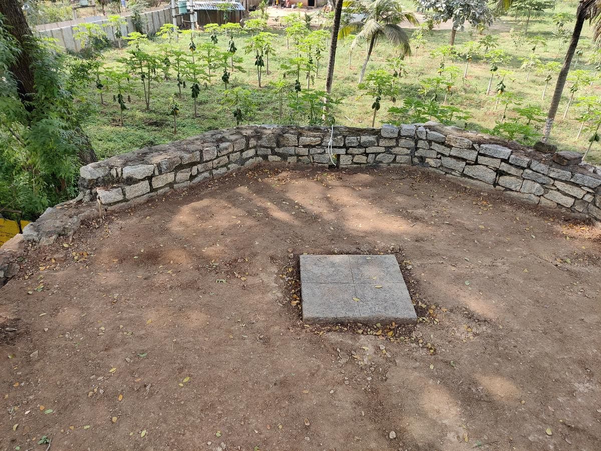
Observatories were built at each end of this new baseline. Sometime in the 1900s, the southwestern observatory was razed and replaced by a marker. The Kannur observatory survived, perhaps by being forgotten.
This unusual stone structure—now dwarfed by factories and schools nearby and almost obscured by vegetation—had broken beams, missing stones, and cracks in its walls.
The marker in the floor pinpointing the exact spot of the 1868 measurement had disappeared but remarkably, a corresponding marker on the roof was still intact.
In December, with permission from the state government, and financial support from Uma Raghavan, a Bengalurean who now lives in the United States, INTACH Bengaluru Chapter began restoring this unique relic of one of the most stupendous scientific endeavours of the 19th century.
(The writer is the author of ‘Discovering Bengaluru’ and the convenor of INTACH Bengaluru Chapter)
Deccan Herald is on WhatsApp Channels| Join now for Breaking News & Editor's Picks